Blog
 “We are pleased to announce today the availability of the Notecard for Skylo — a premiere for Blues and the wireless connectivity industry,” says Rob Lauer of Blues about the module that was unveiled this week at Embedded World 2026 in Nuremberg. “With cellular, Wi-Fi, and satellite in a single Notecard design, it is the only module that combines all of these features with bundled data and no monthly fees.”
Satellite IoT has always faced the same problem: hardware is expensive, subscriptions are painful, and the modules are so large that they require their own project enclosure. Anyone who wanted a tracker that could fall back to a satellite when mobile coverage is unavailable had to count on hardware costs in the hundreds of euros plus $20–$50 in monthly subscription fees per device — before a single byte had even been transmitted.
Blues changed the cost balance on the subscription side a few years ago with their Notecard platform. Now they have also solved the hardware problem with the Notecard for Skylo — and the result is really interesting for anyone developing GPS-tracking products.
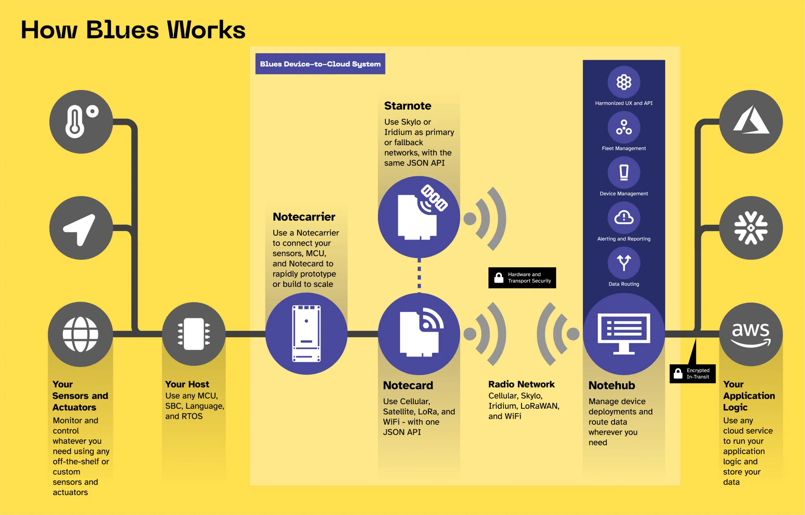
What’s behind it
The Notecard for Skylo (model NOTE-NBGLWX) is a single M.2 module measuring 42 × 30 mm — about the size of a large stamp — and integrates four different connectivity systems in one piece of silicon:
- WLAN (2.4 GHz) — via Silicon Labs WFM200S, integrated ceramic antenna, no external antenna required
- Cellular LTE-M / NB-IoT / GPRS — via Quectel BG95-S5, embedded MFF2-SIM included, 500 MB data volume for 10 years included
- 5G NTN Satellite (Skylo) — same Quectel modem, u.FL antenna connector, 10 KB satellite data included, then usage-based billing
- GNSS — GPS, GLONASS, BeiDou, Galileo, QZSS, u.FL antenna connector
In addition, an LIS2DTW accelerometer is integrated — crucial for tracker design: the module detects movements autonomously and only activates GPS and radio systems if the device is actually moving. In idle mode it consumes under 8 microamps. That’s the difference between two weeks and six months of battery life.
No host microcontroller required for simple tracking. The Notecard for Skylo can autonomously capture and transmit GPS data — configured with only three JSON commands via USB-C. A host MCU is only needed if custom firmware logic such as geofencing or sensor integration is desired.
Why the satellite capability is real
The natural reaction to reading about something as small being satellite-capable is skepticism. That’s understandable. Let’s clear it up directly.
Skylo uses geostationary satellites at an altitude of 35,786 km above the equator — but these satellites carry large, highly sensitive receiving systems. The ground device does not have to be powerful, because the satellite does the heavy lifting on the receiving side. It’s the same principle as GPS: the chip antenna in your smartphone receives signals from satellites 20,000 km away.
Even more important: the modem at the core of this module, the Quectel BG95-S5, was designed from the ground up for 5G NTN (Non-Terrestrial Networks) — the 3GPP standard specifically designed to enable satellite communication with small, energy-efficient ground devices. It is not a cellular chip that was retrofitted for satellites. It is purpose-built for it.
The practical constraint: transmission sessions last 2–10 minutes rather than milliseconds, the module requires a clear view of the sky toward the equator, and peak current during a satellite transmission reaches 400–600 mA — hence the LiPo battery is important. But for a GPS tracker that sends a location ping once per hour, these are not obstacles.
The question isn’t whether the signal reaches the satellite. The limitation is that you send 50–256 bytes at a time, not stream. For GPS coordinates, that is more than enough.
The satellite cost structure explained
This is where it gets interesting for product developers. There is no monthly satellite subscription. The Skylo pricing works like this:
A compact GPS payload — latitude, longitude, accuracy — fits in under 50 bytes when using the required compact template format of the Notecard. That means: each satellite ping costs exactly $0,0375 — the minimum billing. For a tracker that uses satellite only when truly offline (outside Wi-Fi and cellular coverage), monthly satellite costs in most real-world scenarios are between €0 and a few euros.
For comparison: traditional Satellite IoT platforms commonly charge $25–$50 per device per month, regardless of usage. The difference is structural: Blues charges only when the satellite is actually used — and 204 free pings are included in the device purchase.
What it costs in practice per month?
No subscription, no monthly minimum fees. The cellular data volume of 500 MB is included for 10 years. Satellite overage is charged only if the included 10 KB quota is exceeded. For a tracker that operates mainly in urban or suburban areas, ongoing costs are effectively zero.
What you need to build
The minimal hardware list for a functioning GPS tracker is intentionally short. No host microcontroller is required — only the module, a carrier board with a battery charging unit, a LiPo battery, and a case.
Physical dimensions
The Notecarrier X board measures 66 × 38 mm. With a 2000 mAh LiPo next to it and an ABS case, the finished tracker measures about 80 × 40 × 20 mm — smaller than most car keys, weighing around 50–70 grams. Small enough to hide in a vehicle, integrate into a load, or mount in tight positions that conventional trackers cannot reach.
The antennas (two thin flexible strips) sit flat along the inner wall of the plastic case — no external antennas, no drilling required. ABS plastic is radio-transparent, so cellular, Wi-Fi, and GNSS signals pass through the case normally.
Configuration with three commands
This demonstrates what makes the Notecard platform different from pure modem development. No AT commands are written, no network registration is managed. You simply send JSON over USB-C, and the device takes care of everything — network selection, data compression, cloud routing. The entire autonomous tracking configuration consists of three lines:
{"req":"hub.set","product":"com.your.domain:project","mode":"periodic"}{"req":"card.location.mode","mode":"periodic","seconds":3600}{"req":"card.transport","method":"wifi-cell-ntn"}After these three commands, unplug the USB cable. The device operates fully autonomously — location events appear in the Notehub dashboard and can be forwarded to AWS IoT, Azure, MQTT, Google Cloud, or any REST webhook without additional device configuration.
Battery life — what is realistically expected
The numbers are impressive, driven by two design decisions: the sub-8 µA idle current of the Notecard and the integrated accelerometer that only enables GPS and radio when movement occurs.
For most tracking applications — vehicle tracking, freight logistics, asset monitoring in urban or suburban environments — movement-triggered cellular pings cover 95% of operation time, while satellite serves only as an emergency fallback. With this duty cycle, a 2000 mAh LiPo can realistically last well over six months between charging.
What this means for tracking products
At Mapaho Labs we view tracking from both hardware and product perspectives. This release highlights a few points:
- The subscription-free model is truly disruptive. Every cellular IoT product we have evaluated so far carries monthly device fees. The 10-year data plan for the Notecard and the usage-based satellite billing represent a fundamentally different cost structure — one that makes small and niche deployments profitable without the usual subscription risk.
- Satellite as a fallback rather than primary network is the right architecture. Most tracking scenarios don’t require a satellite. But those that do — offshore freight, rural machinery, vehicle tracking in remote areas — need it urgently. Having it as an automatic fallback without a separate module or subscription is a real value-add.
- The form factor enables new enclosure designs. A 66 × 38 mm carrier board with everything integrated is small enough for form factors that were previously not trackable: thinner freight pallets, tighter vehicle mounting positions, smaller devices overall.
- The integrated accelerometer changes the battery calculus. Movement-driven GPS is the difference between a device that lasts weeks and one that lasts months. Having it built into the module means you don’t have to design it yourself.
Important note upfront: NTN satellite communication requires compact Note-File templates that must first be synchronized over cellular with Notehub before the satellite can be used. You cannot access the satellite with a fresh device — an initial cellular synchronization is mandatory. The module also requires a GPS fix and a clear view of the equatorial sky before a satellite transmission can succeed.
Availability and getting started
The Notecard for Skylo is available now in the Blues Shop for $89, the Notecarrier X for $10, and the Notecarrier CX (with integrated STM32 MCU for own firmware) for $17.50. Blues ships internationally.
The official Quickstart Guide walks through the whole process to the first satellite ping in 40–50 minutes. The browser-based terminal enables a cloud platform evaluation with a simulator, even before hardware is ordered. For a product team evaluating this for a concrete use case: the honest advice is to order the module, spend an afternoon with the quickstart, and test the cellular and satellite fallback in your target environment before moving to mass production.
The real variable is Skylo satellite coverage in the target region — this should be checked using the coverage map at skylo.tech before committing.
Resources & Further Links
- 📋 Notecard for Skylo Quickstart Guide — official step-by-step instructions (40–50 min)
- 📄 Full datasheet (NOTE-NBGLWX) — Specs, pinout, coverage maps
- 🛒 Purchase: Notecard for Skylo — $89
- ⭐ Satellite Best Practices Guide — Antenna placement, NTN notes, production tips
- 🌍 Skylo coverage maps — Check satellite availability in your region
- 💬 Blues Developer Forum — Community support, NTN connectivity questions